There is little prospect that the war crisis in the Gulf arena will genuinely calm down in the foreseeable future. If it ever does. On the contrary, according to many indicators, destabilization will intensify. It was not without reason that, in early August 2026, Turkey, Saudi Arabia and Pakistan concluded a “mutual defense agreement.” Many see it as an “Islamic NATO,” perhaps even as a “tripod” from which further expansion and allied military action will emerge.
The boundaries of the conflict may encompass states that have so far remained outside the armed confrontation. As soon as tomorrow, even former (in)formal allies, that is, obedient satellites of the still-leading global power — the United States — could go to war with one another. The flames of war threaten to spread, potentially leading to a merging of the Gulf and Ukrainian battlefields, something that leaders in Kyiv and Jerusalem are calculating as a “lifeline.”
It is not out of the question that things will begin to “boil” throughout the geopolitical “communicating vessels” — from the Middle/Near East, the Eastern Mediterranean and Asia Minor, to the Balkans, the Black Sea basin, and the Caucasus–Caspian region.
THE WAR FIRE CANNOT BE EXTINGUISHED
Increasingly, there is speculation about a possible conflict between Israel and Turkey. There is no doubt that it would not stop at competition for influence in Syria or over its partition, nor at the construction of a “Greater Israel” or the struggle for spheres of influence in the Levant.
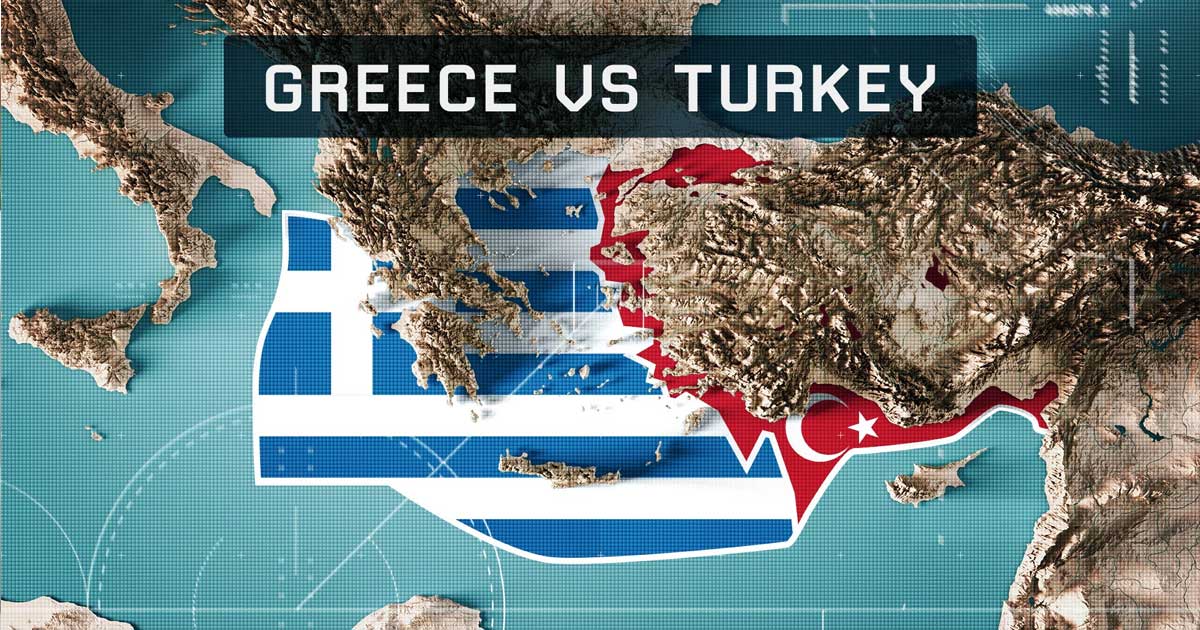
There is a risk of activating the frozen conflict on divided Cyprus, the situation in the eastern Mediterranean will become increasingly turbulent, and the conflict potential in the Aegean will rise to the breaking point, meaning that Greece cannot remain at peace either. And who knows which major “players” will become involved, directly or indirectly.
If a direct Greek-Turkish military confrontation were to erupt, it would mean the outbreak of a war within NATO. This immediately raises the question not only of why the United States, as the undisputed leader of that military alliance, failed to prevent it in time, but also of how it would position itself in a hypothetical confrontation. As a reminder, according to many indicators, Turkey ranks second in the Alliance in terms of military power and holds a key geostrategic position, which is why it is considered NATO’s regional “anchor.” Greece is also often described in these terms, as the United States has increasingly favored and militarily strengthened it since Erdoğan’s Turkey became l’enfant terrible.
In any case, for decades during the bipolar and unipolar periods, the United States managed to discipline Turkey and Greece, maintaining some semblance of balance. This was despite the heavy historical “baggage” of the two subjects — from centuries of harsh Ottoman occupation and the Greco-Turkish War of 1919–1922, including the Greek migration and the so-called Asia Minor Catastrophe, to the conflict in Cyprus that resulted in the island’s division by the “Green Line.” Added to this were disputes over numerous Aegean islands (e.g. Imia, Kastellorizo…) and maritime boundaries, particularly in the context of extending the territorial waters around the Greek islands.
It is precisely the possibility that Greece could, under the 1982 United Nations Convention on the Law of the Sea (UNCLOS), extend its territorial waters from 6 to 12 nautical miles that Turkey has declared a casus belli, and it has issued a very serious and public warning to that effect. Thus, the traditional Turkish frustration over the “injustice” of the Aegean Sea basin not being divided along an approximate median line, in hydrogeographical terms fifty-fifty, has been joined by a new one. It stems from the fact that if the aforementioned extension were to take place, the share of Greek territorial waters in the Aegean would increase from around 35 percent to over 70 percent. Turkey’s share would thus effectively be reduced to a highly geostrategically disadvantaged “outlet to salt water,” i.e. severely restricted access to the open waters of the Mediterranean.

“GEOGRAPHY, ABOVE ALL, SERVES WARFARE”
Yves Lacoste, French geopolitical thinker
This applies particularly to the group of Greek islands extending in an arc between the Epidaurus (Malea) peninsula on the southern coast of the Peloponnese and the Bozburun Peninsula on the southwestern coast of Asia Minor. This is the “3K•R Chain”, consisting of the larger islands of Kythera, Crete, Karpathos and Rhodes. The name of this island chain, given its distinctive position and significance, could also be “the Cretan Arc,” “the Aegean Shield,” or “the Aegean Gateway.”
On one side of it lies, for the most part, the secondary Cretan Sea of the Aegean Basin, which is filled with numerous archipelagos. It is a large Mediterranean “bay” and a Balkan marginal sea, the birthplace of the “First Europe,” which is connected to the Black Sea via the Dardanelles, the Sea of Marmara and the Bosphorus.
On the other side lies the Eastern Mediterranean Basin. Rich deposits of gas and oil have been identified beneath its seabed, and important pipeline routes are planned there. Its waters lap not only against the cradles of earlier and present-day religions/civilizations, but also against the ever-relevant Levant in geo-energy and geopolitical terms. It is crisscrossed by shipping routes leading toward the Suez Canal, one of the world’s key strategic points.
The islands forming the “3K•R Chain” are separated by straits (maritime channels, passages) of delicate strategic importance and highly pronounced conflict potential.
- Between the secondary Peloponnesian peninsula of Epidaurus (Malea) — more precisely, the coastal island of Elafonisos — and the island of Kythera lie Greek territorial waters along the narrow Elafonisos Passage, only 4.5 nautical miles (8.4 kilometers) wide. Considerably more navigable is the Kythera Channel, which separates Kythera and Antikythera and is 8.7 nautical miles wide on either side (17.4 miles in total; around 32 kilometers). This means that extending Greek territorial waters from 6 to 12 miles could result in its closure to Turkish warships. The same applies to the somewhat narrower Antikythera Strait between the islands of Antikythera and Crete (17.3 nautical miles, or approximately 32 kilometers).
- The islands of Kasos and Crete are separated by the Kasos Channel, along which a centuries-old maritime corridor has been established, connecting the southern rim of the Balkans, the Aegean Basin and the coast of Asia Minor with the Middle East and North Africa. Because it is 48.5 kilometers wide, i.e. slightly more than 26 nautical miles, in the event of an extension of Greek territorial waters on both sides, the passage available to Turkish warships could likewise be reduced to only around 2 miles and become extremely risky. Moreover, passage would already be impossible through the narrow strait between Karpathos and Kasos (just under 6 kilometers, or slightly more than 3 nautical miles).
- The Karpathos Channel between Karpathos and Rhodes reduces the passage between the Aegean Sea and the Eastern Mediterranean to slightly more than 23 nautical miles (43 kilometers), which is nevertheless less than the critical combined 12-mile territorial waters on both sides if Greece were to establish them and thus hypothetically blockade Turkish navigation.
- Between the Greek island of Rhodes and the Turkish Bozburun Peninsula lies the Rhodes Strait, only 17.3 kilometers wide, or 9.3 nautical miles. One can only imagine how easily the already tense relations between the two countries could trigger a conflict, let alone Turkey’s ambitions to pass its warships precisely here toward the Eastern Mediterranean, Syria, Israel…
This is, therefore, such an important geographical, civilizational-cultural, geoeconomic and geostrategic configuration that it could bring about a wartime paroxysm in an already overheated world. Accordingly, the Cold War role of the “3K•R Chain,” which at that time was one of the barriers to access by the Soviet navy to the Mediterranean in the narrower sense, could be revived, but in a changed context. This time, in the context of a conflict within the “Collective West,” i.e. particular interests that transcend the common military-security agenda and loyalty to the United States, whose power, and especially its credibility, are becoming increasingly questionable.